Port-Launay, former port on the Loire
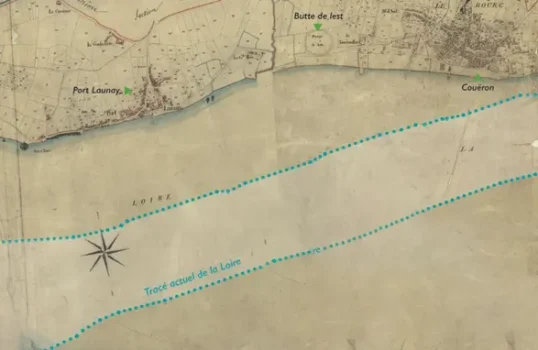
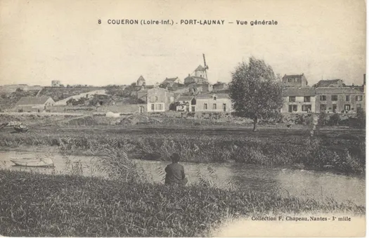
A rocky outcrop, steep, narrow streets running down to the river, houses lined-up as along a quay, the village of Port-Launay resembles other neighbouring small ports on the Loire. But why is it no longer lapped by the river’s waters?
The port of Nantes, one of the main ports on the Atlantic coastline, is situated at the end of the estuary. Navigational difficulties appeared from the 17th century onwards with the combined effects of silting and the increase in ships’ draughts.
Some small ports along the estuary then play the role of fore-ports. The ships drop anchor and the goods are transhipped from ship to ship onto lighter boats. These transhipments are divided according to the ships’ tonnage: the heaviest stop at Paimboeuf, the lighter vessels continue on to Couëron, Indre or even Nantes so as to reduce the heavy costs of transport by scows (flat-bottomed barges).
A real bay…
Between Port-Launay and the town of Couëron, the bay created by a bend in the river is, with Paimboeuf, one of the most active fore-ports in the Loire estuary. From the 16th century onwards, but particularly in the 18th, many ships dropped anchor there.
In a document dating from 1735, we learn that « small ships from Holland, England, Ireland, Spain, Bayonne and elsewhere navigate to this place, whether with goods that they unload onto scows to be carried on to Nantes, and then reload other goods, or empty and only carrying their ballast.« , as the Dutch ships do which mainly load wine from the Nantes region. Couëron is also an important place for the loading of colonial foodstuffs destined for Northern European ports.
Hampered by the silting up of the river, maritime activity decreased at the end of the 18th century. Paimboeuf, which had profited from large-scale development works, conclusively superseded the other ports as the fore-port of Nantes.
Two months in the bay
|

A bay that silts up
The regulations concerning the offloading of ballast not sufficing, development works are undertaken from 1755 onwards. In Couëron, a sandbank begins to form in the bay and will lead to the total distancing of the river one century later.
The village of Port-Launay stretches along the banks and spreads northward to join the unique road to the town of Couëron. The road that runs along the banks of the Loire does not exist yet.
To the east of the village, the Gros Sable, a mound created from ships’ ballasts, built up over the years.
Activities linked to the Loire
The Loire between Le Pellerin (on the left) and Couëron (on the right) by Delusse, 1816, Musée de Ia marine de Loire, Châteauneuf-sur-Loire, Loiret
Mainly, the people of the Loire who live in Port-Launay have activities linked to the river. So in the 18th century in the port of Couëron interact sailors, ferrymen who ensured the crossing of the Loire, scow crews who transported the goods, customs agents posted from the Vair channel to the town, an interpreter, an off-loading agent…

The look of a port
Today the village still looks like a port with its houses lined-up along the road. It also spreads high on the slopes, well-sheltered from the river’s floods.
The varied buildings, dating from the 15th to the 19th century, are composed of small houses and opulent buildings. Some show the age of the constructions: steeply-inclined roofs, window-casings in granite then tufa…
To the north of Port-Launay, one can find the Gerbetière estate, a property owned by the Audubon family from 1781.
Dates
| 1631 | Purchase by the merchants of Nantes of a meadow to be used for offloading ships’ ballast |
| 1643 | Inauguration of a fair in Port-Launay, on Saint Luke’s day |
| 1739 | Ships can only drop anchor in the ports of Paimboeuf, Le Pellerin and Couëron |
| 1755 | Beginning of development works overseen by the Naval Engineer Magin |
| 1769 | First observation of the silting up of the bay |
| 1772 | Nearly 150 ships from Europe weigh anchor at Couëron |
| 1817 | The decision to only authorise transhipments between Nantes and Paimboeuf rather than at Le Pellerin or Basse-Indre marks the decline of the port of Couëron |
| 1859 | Port-Launay is definitively cut off from the river |
| 1875 | Construction of the footbridge allowing one to go from Port-Launay to the ferry’s slipway. |
